Maps & Points of Interest
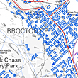
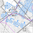
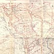
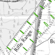
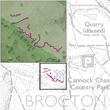
The links featured below show the original layout of Brocton and Rugeley camps (fig. 1 & 2), a range of surviving features from both sites (fig. 4 & 5) and a map of some of the surviving practice trenches around Brocton camp (fig. 6). Figure 3 is a Trench Map of the German fortification on the Messines Ridge where the New Zealand Rifle Brigade fought during June 1917.
|
|
|
1: Large scale map of Brocton camp
|
|
|
|
2: Large scale map of Rugeley camp
|
|
|
|
3: Trench Map of the German fortification on the Messines Ridge
|
|
|
|
|
4: Surviving features of Brocton camp
|
|
|
|
5: Surviving features of Rugeley camp
|
|
|
|
6: Some of the surviving practice trenches on the chase
|
|
|